


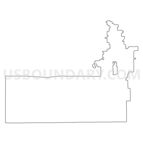
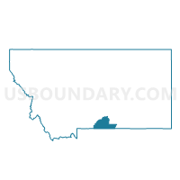
Precinct 11, Carbon County, Montana
About
Outline
Summary
| Unique Area Identifier | 611857 |
| Name | Precinct 11 |
| County | Carbon County |
| State | Montana |
| Area (square miles) | 409.95 |
| Land Area (square miles) | 404.43 |
| Water Area (square miles) | 5.52 |
| % of Land Area | 98.65 |
| % of Water Area | 1.35 |
| Latitude of the Internal Point | 45.11929870 |
| Longtitude of the Internal Point | -109.44601260 |
Maps


Graphs
Select a template below for downloading or customizing gragh for Precinct 11, Carbon County, Montana


Neighbors
Neighoring Voting District (by Name) Neighboring Voting District on the Map
- 5-C Cooke City, Park County, MT
- CLARK-SIRRINE Voting District, Park County, WY
- CRANDALL-PAINTER Voting District, Park County, WY
- Precinct 10, Carbon County, MT
- Precinct 11, Stillwater County, MT
- Precinct 13, Carbon County, MT
- Precinct 16, Carbon County, MT
- Precinct 5, Carbon County, MT
- Precinct 6, Carbon County, MT
- Precinct 7, Carbon County, MT
- Precinct 8, Carbon County, MT
- Precinct 9, Carbon County, MT
Top 10 Neighboring County Subdivision (by Population) Neighboring County Subdivision on the Map
- Cody CCD, Park County, WY (15,648)
- Red Lodge CCD, Carbon County, MT (3,995)
- Absarokee CCD, Stillwater County, MT (2,222)
- Fromberg-Bridger CCD, Carbon County, MT (1,756)
- Gardiner-Cooke City CCD, Park County, MT (1,493)
- Roberts CCD, Carbon County, MT (1,129)
Top 10 Neighboring Place (by Population) Neighboring Place on the Map
Top 10 Neighboring Elementary School District (by Population) Neighboring Elementary School District on the Map
- Red Lodge Elementary School District, MT (3,300)
- Absarokee Elementary School District, MT (1,865)
- Luther Elementary School District, MT (395)
- Fishtail Elementary School District, MT (358)
- Cooke City Elementary School District, MT (97)
Top 10 Neighboring Secondary School District (by Population) Neighboring Secondary School District on the Map
- Red Lodge High School District, MT (3,828)
- Absarokee High School District, MT (2,302)
- Gardiner High School District, MT (1,457)
Top 10 Neighboring Unified School District (by Population) Neighboring Unified School District on the Map
- Park County School District 1, WY (11,915)
- Bridger K-12 Schools, MT (1,304)
- Roberts K-12 Schools, MT (890)
- Belfry K-12 Schools, MT (610)
Top 10 Neighboring State Legislative District Lower Chamber (by Population) Neighboring State Legislative District Lower Chamber on the Map
- State House District 50, WY (10,028)
- State House District 60, MT (10,003)
- State House District 61, MT (9,919)
- State House District 59, MT (9,089)
Top 10 Neighboring State Legislative District Upper Chamber (by Population) Neighboring State Legislative District Upper Chamber on the Map
- State Senate District 30, MT (19,092)
- State Senate District 31, MT (18,534)
- State Senate District 18, WY (18,259)
Top 10 Neighboring 111th Congressional District (by Population) Neighboring 111th Congressional District on the Map
Top 10 Neighboring Census Tract (by Population) Neighboring Census Tract on the Map
- Census Tract 9653, Park County, WY (7,155)
- Census Tract 4, Carbon County, MT (2,259)
- Census Tract 3, Carbon County, MT (2,222)
- Census Tract 9665, Stillwater County, MT (2,222)
- Census Tract 2, Carbon County, MT (1,756)
- Census Tract 5, Park County, MT (1,493)
- Census Tract 5, Carbon County, MT (1,354)
Top 10 Neighboring 5-Digit ZIP Code Tabulation Area (by Population) Neighboring 5-Digit ZIP Code Tabulation Area on the Map
- 82414, WY (15,011)
- 82435, WY (11,738)
- 59068, MT (3,580)
- 59014, MT (1,446)
- 59070, MT (1,047)
- 59028, MT (434)
- 59008, MT (410)
- 59007, MT (113)
- 59071, MT (104)
- 59020, MT (77)